
 Abbottabad:
Abbottabad /əˈbɒtəbɑːd/ (Urdu, Hindko: ایبٹ آباد Ābṭābād [aːbʈaːˈbaːd̪]) is a city located in the Hazara region of the Khyber Pakhtunkhwa province, in Pakistan. The city is situated in the Orash Valley, 50 kilometres (31 mi) northeast of the capital Islamabadand 150 kilometres (93 mi) east of Peshawar at an altitude of 1,260 metres (4,134 ft) and is the capital of the Abbottabad District. It borders Azad Kashmir to the east. The city is well-known throughout Pakistan for its pleasant weather, high-standard educational institutions and military establishments.....
| Abbottabad ایبٹ آباد | |
|---|---|
| — City — | |
| Abbottabad | |
  | |
| Coordinates: 34°9′21″N 73°13′10″E . | |
| Country | |
| Province | |
| District | Abbottabad |
| Elevation | 1,260 m (4,130 ft) |
| Time zone | PST (UTC+5) |
| Calling code | 0992 |
| Number ofUnion Councils | 6 |
| Website | http://www.abottabad.gov.pk |
| Abbottabad District Government | |

History:
The town of Abbottabad, under the British Raj, was the headquarters of the Hazara District during British rule of India. It was named after Major James Abbott who founded the town and district in January 1853 after the annexation of Punjab. He remained the first Deputy Commissioner of the Hazara district from 1849 until April 1853. Major Abbott is noted for having written a poem titled "Abbottabad", before he went back to Britain, in which he wrote of his fondness for the town and his sadness at having to leave it. In the early 20th century, Abbottabad became an important military cantonment and sanatorium, serving as the headquarters of a brigade in the Second Division of the Northern Army Corps.] The garrison consisted of four battalions of native infantry, of the Frontier Force (including the 5th Gurkha Rifles) and two native mountain batteries.
In 1901, the population of the town and cantonment was 7,76] and the income averaged around Rs. 14,900. This increased to Rs. 22,300 in 1903, chiefly derived from octroi. During this time chief public institutions were built such as the Albert Victor unaided Anglo-Vernacular High School, the Municipal Anglo-Vernacular High School and the Government dispensary. In 1911, the population had risen to 11,506 and the town also contained four battalions of Gurkhas.
In June 1948, the British Red Cross opened a hospital in Abbottabad to deal with thousands of patients who were being brought in from the Kashmir fighting areas.
In October 2005 Abbottabad was devastated by the Kashmir earthquake. Although most of Abbottabad survived, many older buildings were destroyed or severely damaged.
In May 2011, Abbottabad gained worldwide attention when U.S. President Barack Obama announced that Osama bin Laden had been killed in his compound in the city.[Later, Pakistani authorities demolished the house where Osama bin Laden lived for years.

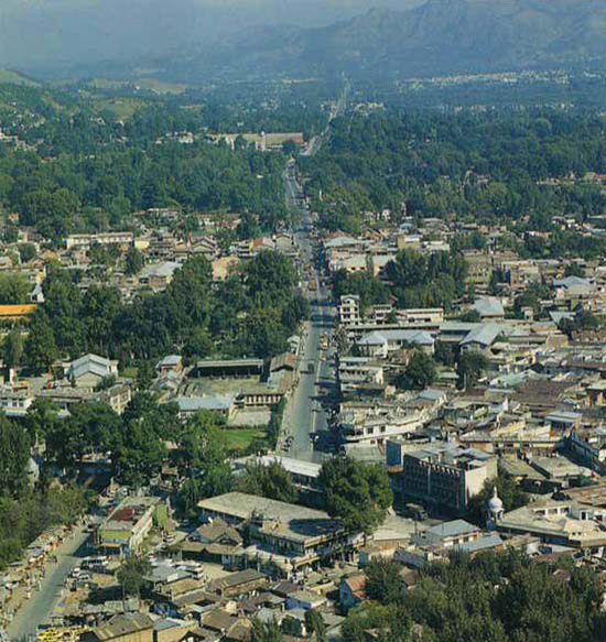
Geography:
The city is bounded at all four sides by the Sarban hills, from which residents and tourists can see breathtaking views of the region and city. The location of the city and the hills allows Abbottabad to experience pleasant weather in the summer and cold winters. The Dor river flows south of Abbottabad through the town of Harnol, eventually reaching Tarbela Dam, situated west of Abbottabad. Neighbouring districts are Mansehra to the north, Muzaffarabad to the east, Haripur to the west and Rawalpindi to the south.
[edit]Topography
Abbottabad is situated in the Orash Valley lying between 34°09′N latitude and 73°13′E longitude at an altitude of 4,120 feet (1,260 m).
[edit]Climate
Abbottabad has a humid subtropical climate, with mild to warm temperatures during the spring and autumn months, hot temperatures during June and July and cool to mild temperatures during the winter. The temperature can rise as high as 35 °C (95 °F) during the mid-summer months and drop below 0 °C (32 °F) during the winter months. Snowfall can occur in January, though it is sparse, while the rare occasion of rainfall occurs during the short monsoon season stretching from July to September and frequently causes flooding.
| [hide]Climate data for Abbottabad, Pakistan | |||||||||||||
|---|---|---|---|---|---|---|---|---|---|---|---|---|---|
| Month | Jan | Feb | Mar | Apr | May | Jun | Jul | Aug | Sep | Oct | Nov | Dec | Year |
| Average high °C (°F) | 12 (54) | 14 (57) | 18 (64) | 23 (73) | 28 (82) | 33 (91) | 30 (86) | 28 (82) | 28 (82) | 25 (77) | 20 (68) | 15 (59) | 22 (72) |
| Average low °C (°F) | 2 (36) | 4 (39) | 8 (46) | 12 (54) | 16 (61) | 20 (68) | 20 (68) | 19 (66) | 17 (63) | 13 (55) | 8 (46) | 4 (39) | 11 (52) |
| Precipitation mm (inches) | 73 (2.87) | 103 (4.06) | 123 (4.84) | 104 (4.09) | 73 (2.87) | 77 (3.03) | 247 (9.72) | 244 (9.61) | 96 (3.78) | 51 (2.01) | 31 (1.22) | 47 (1.85) | 1,269 (49.96) |
| Source: Weatherbase[11] | |||||||||||||
Languages
According to the 1998 Census of the 881,000 who resided in the Abbottabad District, Hindko was spoken by 94.26% of the population, followed by Potohari at 2.30%, Pashto at 2.22% and Urdu at 1.05%.Although the first language of most people in the district is Hindko, Urdu is understood and spoken fluently by majority of the residents and used in markets, offices and formal functions as the official language. English is widely used in business and education.
Government:
Abbottabad is the headquarters of Hazara Division and Abbottabad District. The District Nazim, Commissioner, Inspector General and Forest Conservator all reside in Abbottabad. The city is divided into localities, towns, colonies and neighbourhoods. In addition to the civil administration, the town is also the regimental headquarters for the Frontier Force Regiment, the Baloch Regiment and Pakistan Army Medical Corps.
Tourism:
Abbottabad has been attracting tourists to the city since the colonial era, as it is a major transit point to all major tourist regions of Pakistan such as Nathiagali, Ayubia and Naran. According to the Imperial Gazetteer of India, "the town is picturesquely situated at the southern corner of the Rash (Orash) plain, 4,120 feet (1,260 m) above the sea".
Like much of the mountainous Northern Areas, tourism is one of the important sources of income in Abbottabad. In the summer when temperatures rise to around 45 degrees Celsius in Punjab andKhyber Pakhtnkhwa, a large number of tourists travel to Abbottabad.
| thandani |
| muree |
Abbottabad is popular not just with visitors but with those looking to relocate. Its weather, peaceful reputation and the perceived security of a garrison have drawn many from other cities to work or educate their children. There was an influx of migrants from Azad Kashmirafter the 2005 Kashmir Earthquake, another from Swat during military operations against militants in 2009 and 2010, and also fromWaziristan after the army launched major operations against the Taliban in 2009.
Some popular tourist destinations in and around Abbottabad include: - Ayubia National Park
- Bara Gali
- Dor River Valley (at Harnoi/Harnol)
- Dunga Gali
- Ilyasi Mosque
- Khaira Gali
- Nathia Gali
- Shimla Hill
- Thandiani
 |
| Ilasi Mosque |
 |
| Hornoi |
ABBOTTABAD is really Famous for:
- Abbottabad (poem)
- Army Burn Hall College
- Ayub Medical College
- Kakul
- St. Luke's Church, Abbottabad
- Ayubia National Park
- Bara Gali
- Dor River Valley (at Harnoi/Harnol)
- Dunga Gali
- Ilyasi Mosque
- Khaira Gali
- Nathia Gali
- Shimla Hill
- Thandiani
 |
| james abbott |
POEM ABOUT ABBOTTABAD BY:JAMES ABBOTT
I remember the day when I first came here
And smelt the sweet Abbottabad air
The trees and ground covered with snow
Gave us indeed a brilliant white glow
To me place seemed like a dream
And far ran a lonesome stream
The wind hissed as if welcoming us
The pine swayed creating a lot of fuss
And the tiny cuckoo sang it away
A song very melodious and gay
I adored the place from the first sight
And was happy that my coming here was right
And eight good years here passed very soon
And we leave our perhaps on a sunny noon
Oh! Abbottabad we are leaving you now
To your natural beauty do I bow
Perhaps your wind's sound will never reach my ear
My gift for you is a tear
I bid you farewell with a heavy heart
Never from my mind will you memories thwart
James Abbott.

Pakistan Military Academy

http://pafnp.blogspot.com/2012/01/pakistan-military-academy-pakistan.html
Tribes of Abbottabad
Tanoli
Karlal
Awan
Jadoon
Sarrara
Utmanzai
Dhund Abbasi
RADIO PAKISTAN ABBOTTABAD(FM 93)
 |
| RADIO PAKISTAN ABBOTTABAD(FM 93) |

0 comments:
Post a Comment